2017 News Archive
Subsalt Oil in the Atlantic - the New Eldorado? (December 12, 2017)
In the last few years, subsalt offshore exploration in the Southern Atlantic opened up new giant hydrocarbon provinces, both on the African and the South American side. For decades, the thick Aptian (ca. 100 Ma) salt along both passive margins had been the impenetrable floor for oil exploration; diapirs and salt pillows provided numerous traps in the postsalt sediments, commonly Upper Cretaceous carbonates and Cenozoic clastics. In Brazil, for example, shallow fields in the offshore basins of Campos, Santos and Espirito Santo had been and are still exploited. In 2005, exploring the subsalt potential started with a first exploration well targeting presalt reservoirs in deep waters. Since then, more than 25 discoveries have been reported in the presalt column with a total recoverable resource of >30 billion barrels (bbl). Current subsalt production is at ~926,000 bl/d.
One remarkable discovery (2012) is the Pao de Acucar accumulation in the Campos Basin (Vieira de Luca et al. 2017). The Campos Basin originated by off-axis rifting in the Jurassic. Thinned metamorphic basement is overlain by tholeiitic volcanic rocks such as subaqueous pillow lavas and laminated volcanoclastics. Horsts and grabens controlled the subsequent sedimentation of shallow microbial carbonates, fine grained siliciclastics and chemical sediments deposited in an alkaline/saline lake that evolved during the thermal sag phase of the basin. On top and laterally of this shallow lake suite, a ca. 100 m thick layer of calcic-dolomitic laminated organic-rich shales is thought to represent a deep lacustrine facies that sourced the hydrocarbons. The terrestrial sediments are overlain and sealed by the marine evaporites of the Aptian salt.

- Photograph showing the Bay of Botafogo and the Pao de Acucar, which is the Portuguese name for Sugarloaf Mountain at Rio de Janeiro, Brazil. Credit to Wikimedia Commons: Courtesy Halley Pacheco de Oliveira.
At Pao de Acucar, innovative interpretation of old and new seismic data showed a broad antiformal hill that was chosen as the target for a first well. The well revealed three microbial carbonatic sequences on top of a volcano-tectonic high (a carbonate platform according to the authors), that interfinger downslope with the shales of the Upper A source rock unit. The subsalt column is peculiar because of pervasive hydrothermal brecciation and alteration, mainly silicification, that induced favourable reservoir properties including ~13 % porosity. Hydrocarbon generation post-dates the hydrothermal event. The hydrocarbon reservoir comprises fractured basalt and silicified vuggy carbonates that contain a productive hydrocarbon column of nearly 500 m, with valuable light oil (42 to 46 degrees API), condensate and gas. The source rock has total organic carbon (TOC) varying from 2 to 6%. With values of up to 900 mg HC/g Corg the hydrogen index (HI) indicates type I algal kerogen. Resources are estimated at 700 million bl of light oil and 3 Tcf3 of gas (Vieira de Luca et al. 2017).
Pao de Acucar in the Campos Basin is an impressive subsalt discovery, in ultradeep waters offshore Brazil at depths ranging from 2500 to 2900 m. It is peculiar because the reservoir pore space originated by hydrothermal replacement of carbonates by silica. The field's feasibility is not yet established and the challenges to overcome are considerable, concerning geological, technical and financial issues (Vieira de Luca et al. 2017). At present, the competition with unconventional oil in the USA seems to be in favour of the latter, but this may change. Obstacles will be resolved. I believe that we are observers of the birth of a new Eldorado of black gold.
Reference
Vieira de Luca, P. H., Matias, H., Carballo, J., Algibez Alonso, J. L., Tritlla, J., Esteban, M. et al. (2017) Breaking barriers and paradigms in presalt exploration: The Pao de Acucar discovery (offshore Brazil). In R. K. Merrill & C. A. Sternbach (eds), Giant fields of the decade 2000-2010. AAPG Memoir 113, 177-194.
Back to top
Home
Australian Ore Deposits - Monumental! (November 17, 2017)
Would you know a book that describes the ore deposits of a whole continent? A book that provides overview papers summarising regional geology and mineralisation for the different geological provinces and hundreds of descriptions of existing mines; articles arranged according to major geological provinces; papers being descriptive and intended to provide long-lasting data and information including geochemical and geophysical aspects; containing informative commodity overviews (W.A. Ni and Fe, Critical Metals, rare element pegmatites, Au, heavy mineral sand deposits in Australia, and major mining districts of (inter)national significance (e.g. Greenbushes Sn-Ta-Li, Mt. Weld REE, Golden Mile Au, Boddington-Wandoo Au, Mt. Tom Price Fe, channel iron deposits, Mt. Isa Cu-Pb-Zn-Ag and numerous others). For detailed Content, please refer to the URL provided below.
Here is one of these extremely rare species, just published:
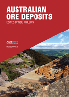
- Phillips, N. (ed) (2017) Australian ore deposits. Monograph 32, 6th ed. 879 pp. Australasian Institute of Mining and Metallurgy. The book can be bought as a hard copy, or in CD or USB format. Non-members of AusIMM are charged 190-160 A$, students 80 A$. URL www.ausimm.com.au/publications
My interest in Kiruna-type iron oxide-apatite (IOA) and related iron oxide-copper-gold (U-REE) (IOCG) ore deposits (see my blog News El Laco Iron Ore: Conflicting Genetic Models /August 8, 2017) made me look up first the article on the giant Olympic Dam iron oxide Cu-U-Au-Ag deposit by Ehrig et al. (2017).
You do know, of course, that Olympic Dam is the type deposit of the iron oxide-copper-gold (IOCG) clan which attribution was subsequently given to numerous deposits globally? I was curious to read the update and summary observations on the name-sake deposit.
After introducing the history of discovery and development, Ehrig et al. (2017) provide the latest reserve and resource figures for the deposit: Total resource (2016) is 10,000 Mt at 0,77 % Cu, 250 ppm U3O8, 0.32 g/t Au, and 1 g/t Ag. Proven reserves amount to 150 Mt @ 2% Cu, 620 ppm U3O8, 0.63 g/t Au and 5 g/t Ag. This is followed by summaries of previous work, regional setting, local geology and alteration. The main alteration minerals are hematite, magnetite, muscovite and quartz. Details on alteration and mineralisation mineralogy and distribution are provided and illustrated. U-Pb ages of hydrothermal uraninite and hematite are within error equal to magmatic zircon of the Roxby Downs granite establishing (my words) a strong parental relation.
I wonder, how many deposits of the IOCG clan resemble Olympic Dam by more properties than the paragenesis of magmatic-hydrothermal hematite and sulfides?
Reference
Ehrig, K., Kamenetsky, V.S., McPhie, J. et al. (2017) Olympic Dam iron oxide Cu-U-Au-Ag deposit. Pp 601-609 in Australian ore deposits (ed G.N. Phillips), Australasian Institute of Mining and Metallurgy.
Back to top
Home
Run-away climate? Is Limestone the Salvation? (October 26, 2017)
Already today, limestone is an eminently essential material in environmental engineering. A new role is envisaged for controlling climate warming. You know that apart from reducing emissions, various techniques of solar geoengineering, also called climate intervention or climate engineering are considered.
The argument is that injecting aerosols or aerosol precursors (such as CaCO3 or SO2) into the stratosphere or near the base of clouds can shield the Earth's surface from incoming radiation and thus provide a negative forcing of the temperature and offset the positive forcing due to increased greenhouse gas concentrations. Volcanic eruptions provide natural examples of this effect. In June 1991, Mt. Pinatubo blew ~10 Mt of sulfur into the stratosphere and caused detectable cooling without disruption of the climate system. Another method might be fertilizing the high oceans with iron in order to amplify biomass production enhancing carbon storage by burial of organic matter in ocean floor sediments. Such actions could slow warming and provide time for the huge investments needed to reduce human CO2 emissions and to mitigate consequences of climate change.
The recent proposal by a group of scientists from Havard University is a great improvement on earlier thoughts. They demonstrate that calcite aerosol geoengineering may cool the planet while simultaneously repairing the ozone layer (Keith et al. 2016). For more detail, read their Abstract:
Injecting sulfate aerosol into the stratosphere, the most frequently analyzed proposal for solar geoengineering, may reduce some climate risks, but it would also entail new risks, including ozone loss and heating of the lower tropical stratosphere, which, in turn, would increase water vapor concentration causing additional ozone loss and surface warming. We propose a method for stratospheric aerosol climate modification that uses a solid aerosol composed of alkaline metal salts that will convert hydrogen halides and nitric and sulfuric acids into stable salts to enable stratospheric geoengineering while reducing or reversing ozone depletion. Rather than minimizing reactive effects by reducing surface area using high refractive index materials, this method tailors the chemical reactivity. Specifically, we calculate that injection of calcite (CaCO3) aerosol particles might reduce net radiative forcing while simultaneously increasing column ozone toward its preanthropogenic baseline. A radiative forcing of −1 W⋅m−2, for example, might be achieved with a simultaneous 3.8% increase in column ozone using 2.1 Tg⋅y−1 of 275-nm radius calcite aerosol. Moreover, the radiative heating of the lower stratosphere would be roughly 10-fold less than if that same radiative forcing had been produced using sulfate aerosol. Although solar geoengineering cannot substitute for emissions cuts, it may supplement them by reducing some of the risks of climate change. Further research on this and similar methods could lead to reductions in risks and improved efficacy of solar geoengineering methods.
Is this not a wonderful innovation? The paper is Open Access classified, so you can and should read it in full length. The authors calculate for 1 Mt (million tonnes) of calcite per year; compared to a global production of ca. 300 Mt of lime and Ca-hydrate per year, the resources of calcite (limestone) should easily support such a program.
Reference
Keith, D.W., Weisenstein, D.K., Dykema, J.A. & Keutsch, N. (2016) Stratospheric solar geoengineering without ozone loss. Proceedings of the National Academy of Sciences (PNAS) 113, 14910–14914. Open Access. http://www.pnas.org
Back to top
Home
Innovation in Digital 3D Surveying and Geological Mapping of Steep Terrain (September 6, 2017)
A provocative paper in the last Issue (9/2017) of GSA Today (Pavlis & Mason 2017; see below) declares the dawn of a new mapping age, using available and yet-to-be-developed equipment and software, halting the decline of mapping capability.
Today, cliffs, rock walls and steep opencast slopes are often surveyed with ground-based LIDAR (light detection and ranging) scanners. Orthophoto-like images are routinely made for surveying pits and the mine near-field with unmanned aerial vehicles (UAVs or ‘drones’).
Pavlis & Mason (2017) describe how in steep mountains, canyons (or mines), Structure from Motion (SfM or multi-view) stereo photogrammetry in conjunction with UAVs, allows construction of inexpensive, high-resolution, photorealistic 3D terrain models. Using appropriate software, these models support the next generation of true 3D geological mapping.
The authors present a case study with work flow applied to complexely folded basement in Surprise Canyon, California, USA. They have a number of proposals how to drive this evolution further, such as the development of a low-cost, lightweight drone that could become every geologist's ‘field assistant’. Multi- and hyperspectral sensors for UAV will potentially lead to a “geologist's ability to develop 3D lithological classification maps in the field - giving them live, multispectral eyes.” Not always is it clear for a quick reader, which part of the visions is already possible now, and what is expected for the future.
Let the authors speak for themselves:
CONCLUSIONS Three-dimensional terrain models derived from SfM, particularly when augmented with aerial photography from UAS, provide an inexpensive base for the next generation of geologic mapping using a 3D interface. Visualization of these models frees geologists from the confines of flat maps and allows high-precision mapping of steep slopes and cliffs, which are virtually invisible in conventional maps. The ability to easily examine multiple view angles of Earth's 3D surface outside the time limitations and logistical constraints of fieldwork is a cognitive breakthrough that frees field geology from the one-site — one-visit paradigm. Many geologists have lamented the decline of field geology, but the rise of these 3D technologies has a potential to revitalize field geology and launch a new generation of studies. Research is desperately needed, however, on ideal workflows that employ this technology across a range of applications and the range of field sites, and perhaps most importantly, how this technology can aid 3D learning rather than hinder it.
References
Pavlis, T.L. & Mason, K.A. (2017) The new world of 3D geologic mapping. GSA Today 27, no. 9, 4-10. DOI: 10.1130/GSATG313A.1
Back to top
Home
El Laco Iron Ore: Conflicting Genetic Models (August 8, 2017)
No one working in economic geology can miss the observation that often, genetic interpretations are contradictory. Opposing hypotheses exist for decades, and new papers promoting one view soon provoke new arguments from the other side.
Such a case is the origin of the Kiruna-type iron oxide-apatite (IOA) ore deposits: traditional genetic model of essentially orthomagmatic origin is opposed by recurring hydrothermal replacement hypotheses. The Kiruna district in Sweden is geologically ancient and complex. Maybe the youngest of the family can illuminate us, represented by iron ore on the Pliocene-Pleistocene El Laco stratovolcano of andesitic to dacitic composition in the High Andes of northern Chile?
On the flanks of El Laco volcano (5325 m a.s.l.), there are seven large deposits of high-grade iron ore within an area of 30 km2, with total resources exceeding 1500 million tonnes. The ores are composed of magnetite (or martite), and minor amounts of hematite, anhydrite, apatite and pyroxene.
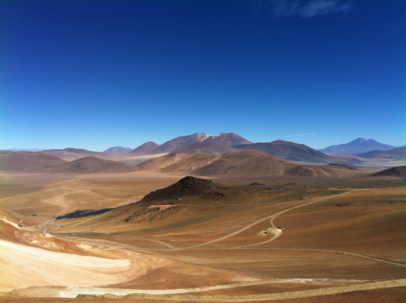
- Black magnetite ore outcrop on the flank of El Laco volcano, Chile. Credits to Matthias Benz / Germany / www.world-of-crystals.com/
In the early 1960s the first published report on the El Laco iron ore described lava-like magnetite flows but later exploration work showed that beneath the hard surface, friable ore of pyroclastic appearance is predominant. Several papers published around the year 2000, however, proposed a hydrothermal replacement origin.
In 2015-2017, four independent papers were published that substantiate an orthomagmatic-extrusive and pyroclastic formation of the El Laco ore. Tornos et al. (2016) confirm macroscopic observations that textures of massive ore are strikingly similar to those of vesicular low viscosity basalt and report O-isotopic data from El Laco suggesting that basalt-like iron oxide ore blankets are in fact solidified melts; plagioclase phenocrysts in andesite, for example, contain melt inclusions with two immiscible melts, one of silicates, the second rich in iron and with small tenors of Ca, Mg, Si, Ti, and P; this confirms the segregation of an ore melt. During quenching, the iron oxide melt released large volumes of super-hot volatiles (>900o C) and some hydrosaline melt. The latter caused magmatic-hydrothermal alkali-calcic alteration of the host andesite, which is similar to IOCG related alteration, providing the main argument for a possible hydrothermal replacement origin. HF-rich vapor produced a cap of acid-sulfate steam-heated alteration. In the latest of a long string of papers on El Laco and Kiruna, Nyström & Henriquez (2016) point out that the El Laco deposits are the best preserved examples of apatite iron ore of Kiruna type in the world. They illustrate convincingly features of ore such as vesicles and subvertical tubes that confirm widespread degassing during crystallization. Peculiar spherules of octahedral magnetite in the volcanic ash imply formation by rapid crystal growth in a gas plume during eruption of iron-oxide melt. Together, the new papers provide a vivid tableau of orthomagmatic-extrusive and pyroclastic formation of iron ore at El Laco.
A third paper by Knipping et al. (2015) proposed a continuous transition from magmatic to hydrothermal processes and magnetite flotation as the best-fitting genetic model for Kiruna type iron oxide apatite (IOA) ore deposits. This model explains the random spatial distribution of Kiruna-type iron oxide-apatite (IOA) and of iron oxide-copper-gold (U-REE) (IOCG) ore deposits in the Cretaceous Chilean iron ore belt. The two deposit types may be formed from one magmatic system, at depth the IOA mineralisation, and nearer to the surface, the IOCG system. The erosion level determines what we see. In a forth paper, Barra et al. (2017) show a scheme of this arrangement in their Fig. 2. They report that Re-Os data of the Chilean deposits suggest a crustal source for both the IOA and IOCG mineralisation. Should we not have expected a mantle derivation?
Is this the final word? - In spite of the admirable work presented above, it is not. Science continues to ask questions. Novel technologies will be developed and applied. Science and innovation are processes that will never end. Modified or radically new models will be built on the assembled knowledge and on new data. Let us always be prepared for change!
References
Barra, F., Reich, M., Selby, D. et al. (2017) Unraveling the origin of the Andean IOCG clan: A Re-Os isotope approach. Ore Geology Reviews 81, 62–78.
Knipping, J.L., Bilenker, L.D., Simon, A.C. et al. (2015) Giant Kiruna-type deposits form by efficient flotation of magmatic magnetite suspensions. Geology 43, 591-594. geology.gsapubs.org
Nyström, J.O., Fernando Henríquez, F., Naranjo, J.A. & Naslund, H.R. (2016) Magnetite spherules in pyroclastic iron ore at El Laco, Chile. American Mineralogist 101, 587–595.
Tornos, F., Velasco, F. & Hanchar, J.M. (2016) Iron-rich melts, magmatic magnetite, and superheated hydrothermal systems: The El Laco deposit, Chile. Geology 44, 427-430. DOI 10.1130/G37705.1
Back to top
Home
Sea-floor pockmark fields have widely varying origins (July 18, 2017)
The search for petroleum and natural gas strives for a geological synthesis of basin evolution and related petroleum and gas systems in space and time (4D). A wide choice of tools and methods is used for attaining this goal. Because many oil and gas deposits are leaky, understanding hydrocarbon seeps and vents is always of high interest.
Sea floor pockmarks are curious features that are commonly attributed to venting of methane. They are crater-like structures that originate by fast gas flow or eruptions. Diameters vary up to >1000 metres. Globally, pockmark fields comprise huge numbers of dispersed vents that occupy large areas of continental slopes and shelfs. As it happens, two papers describing and analysing the origin of pockmark fields have recently appeared, one concerning the Santos Basin offshore Brazil (de Mahiques et al. 2017; open access) and the other the northern North Sea offshore Norway (Mazzini et al. 2017). The interpretations of the mechanisms behind their formation and dynamics could not be more different. Please read on:
The Santos Basin is part of the new giant hydrocarbon province offshore Brazil. A great role has Aptian (Early Cretaceous) salt as a seal and a structural agent. Diapirs intrude Mesozoic and Cenozoic sediments (Fig. 6). Some of them control hydrocarbon fluid flow from a sub-salt source to the ocean floor where the pockmarks have been found. The authors suggest that repeatedly, halokinesis enhanced the escape of fluid/gas from the subsurface to the water column. The main argument for this causal relation is the arrangement of the ca. 1000 pockmarks along diapir borders and related faults (de Mahiques et al. 2017).
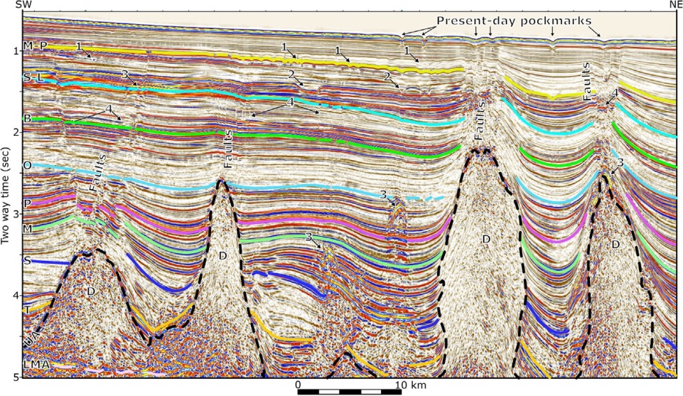
- Localisation of pockmarks along diapir borders and related faults (Fig. 6 of de Mahiques et al. 2017). Note older, buried pockmark layers marked (1). D are salt diapirs. Seismic reflection section courtesy de Mahiques et al. 2017.
The second paper introduces one of the World's largest pockmark fields located in the Troll region in the northern North Sea (Mazzini et al. 2017). Here, >7000 pockmarks are present in a ∼600 km2 area and many more likely occur over a 15,000 km2 region outside the study area. The vent distribution is irregular. No relation to the offshore gas field Troll ca. 80 km NW of Bergen, Norway, can be established. Troll contains giant gas reserves and considerable oil. The field lies on the eastern flank of the Jurassic Viking graben, in sandstones of the Middle to Late Jurassic Viking Group. Source rocks are Kimmeridgian Draupne shales in deeper parts of the graben in the West.
Geochemical data from carbonate blocks collected from Troll pockmarks indicate a methanogenic origin linked to gas hydrate dissociation and past fluid venting at the seafloor. Carbonates collected from the vents gave an U—Th isochron age of 9.59±1.38 ka, i.e. the initial Holocene. The authors suggest that deglaciation could have triggered dissociation of gas hydrates formed during the last ice age in the region, as warming caused degassing of a methane hydrate layer below the seafloor. They stress the role of rapid warming following the Younger Dryas in affecting the marine gas hydrate reservoir (Mazzini et al. 2017).
References
de Mahiques, M.M., Schattner, U., Lazar, M. et al. (2017) An extensive pockmark field on the upper Atlantic margin of Southeast Brazil: spatial analysis and its relationship with salt diapirism. Heliyon 3 (2017) e00257. Open access. DOI 10.1016/j.heliyon.2017.e00257
Mazzini, A., Svensen, H.H., Forsberg, C.F. et al. (2017) A climatic trigger for the giant Troll pockmark field in the northern North Sea. Earth and Planetary Science Letters 464, 24-34. doi.org/10.1016/j.epsl.2017.02.014
Back to top
Home
Bauxite in China: The Product of a Mantle Plume? (June 15, 2017)
Impossible! Or not? What would be your answer? Well, read the facts below, and let us come back to this hypothesis at the end:
Most of China's bauxite production is derived from karst deposits. One example of a bauxite mining province is western Guangxi in the South China Block, where resources comprise more than 500 Mt including Permian bauxite ore and its quaternary derivatives ( Liu et al. 2017). The bauxite province is adjacent to the mantle-plume-related Emeishan Large Igneous Province (LIP, formed at 262–257 Ma) that displays voluminous mafic lavas, mafic-ultramafic intrusions, rhyolites and A-type granites. At about the end of the Middle Permian, part of the shallow marine carbonate platform in the region was uplifted and karstified. On this karst surface, ash (?) and sediments derived from the Emeishan LIP were deposited. Bauxite formed during the Capitanian greenhouse event (ca. 265–254 Ma). Soon afterwards, the bauxite was buried underneath Late Permian and Triassic marine carbonate and clastic sediments. At the Pingguo bauxite deposit, cryptocrystalline or ooidal bauxite ore consists of diaspore, pyrite and anatase. Underneath the transgressive hanging wall limestone, kaolinite contents are elevated. The Emeishan source basalts bequeathed Fe and Mg as well as strontium, neodymium and lead isotopic characteristics. Pyrite sulfur isotopic compositions (−34.11 to −18.91‰) reflect the microbial sulfate-reducing activity during diagenesis. Generally, many bauxite deposits demonstrate early oxidizing and acidic conditions followed by reducing and alkaline conditions. Evidence of microbial activity during formation and diagenesis at Pingguo is confirmed by images of fossilized microbes (Liu et al. 2017).
Back to the Emeishan mantle plume: I suggest that indeed its activity caused (1) directly the emergence of the marine carbonate platform; (2) indirectly, by emission of CO2, the elevated temperatures and rainfall of the Capitanian greenhouse favouring karstification; and (3) the provision of basalt-derived sediments.
The sober authors did not write down this speculation but provided the elements for the synthesis of this metallogenetic system. They deserve our praise!
Reference
Liu, Xuefei, Wang, Qingfei, Zhang, Qizuan et al. (2017) Genesis of the Permian karstic Pingguo bauxite deposit, western Guangxi, China. Miner. Deposita (as yet no volume no. attributed). DOI 10.1007/s00126-017-0723-y
Back to top
Home
Geofluids: Brief Review of an Excellent New Book (20 May, 2017)
This is a wonderful book for all whose work concerns fluid and melt inclusions. Hurai et al. 2016 (citation below) cover the essential theory and the interpretation of inclusions analysis. For many themes, they provide worked examples of calculations (e.g. on page 183, Problem 6.2 Calculating oxygen fugacity from fluid composition). Explanations are patient, illuminating and readable. Numerous figures, mainly b/w line drawings help understanding. I believe that for users with a base in physical chemistry, the book should be suitable for self-learning. I am certain, that academic teachers and students will enjoy this book.
Chapters of the book: General Characteristics — Phase Diagrams — Equations of State — Microthermometry — Interpretation of Microthermometric Data — Thermodynamics — Raman and Infrared Spectroscopic Anlysis - Miscellaneous Methods (including crsuh-leach analysis) — Stable Isotopes — Seven Appendices (Tables with equations of state, stable isotope fractionation equations, and Raman identification tables that aid in identification of inclusion solids).
Ties to geological systems are frequently provided, e.g. hydrocarbons in fluid inclusions, the C-O isotope composition of carbonatite crystallization/devolatilization, graphite as a single-mineral geothermometer, the effect of fluid-rock interactions, or of hydrothermal alteration. Concluding the Stable Isotope Chapter, eight pages are devoted to the description of the metasomatic and vein siderite and magnesite mineralisation in the Western Carpathians (the Alpine belt in Slowakia). I happen to know the western extension of this province in Austria reasonably well (you may scan my list of publications). The authors use stable isotopes and fluid inclusions to weigh the evidence for competing genetic models: i) the older orogenic/metamorphic saline fluid hypothesis; and ii) the more recent evaporative brine convection hypothesis (Prochaska 2012). They conclude that high-pressured fluid inclusions combined with carbon and oxygen isotope data affirm the metamorphogenic model and contradict both the brine infiltration model and a genetic connection between siderite and magnesite (Hurai et al. 2016).
This is a worthy successor to Roedder's classic ‘Fluid inclusions’ and an admirable summary of all the work done since. With a very different appoach, however, it is not an update of the other classic on geofluids: Fyfe et al. (1978) “Fluids in the Earth's crust”.
References
Fyfe, W.S., Price, N.J. & Thompson, A.B. (1978) Fluids in the Earth's crust. 383 pp. Elsevier.
Hurai, V., Huraiova, M., Slobodnik, M. & Thomas, R. (2016) Geofluids - Developments in Microthermometry, Spectroscopy, Thermodynamics, and Stable Isotopes. 504 pp. Elsevier. www.elsevier.com
Prochaska, W. (2012) Siderite and magnesite mineralisations in Paleozoic strata of the Eastern Alps (Austria). J. Alpine Geol. 54, 309-322.
Roedder, E. (1984) Fluid inclusions. Reviews in Mineralogy 12, 644 pp. Mineral. Soc. America, Washington.
Back to top
Home
Mineral prospectivity modelling — its essence and limitations (20 April 2017)
Modern mineral prospectivity modelling relies on a process-based, or ‘mineral systems’ approach using Geographic Information Systems (GIS), which was developed in Australia during the last two decades (Hagemann et al. 2016a). Mineral system analysis (MSA) is a holistic genetic investigation that identifies all factors and processes that contribute to the origin and preservation of a mineral deposit, emulating (conventional) petroleum systems ( see Figure). For exploration, target models are based on the underlying mineralization processes and their mappable features.
The critical mineralization processes acting together to form a hydrothermal ore deposit, for example, may include (a) the establishment of an energy gradient to drive the system; (b) the generation of hydrothermal fluids; (c) the extraction of metals and chemical ligands for metal complexation from suitable sources; (d) the transport of fluids and metals from source regions to traps (i.e. effective flow channels); (e) deposition of metals triggered by chemical and physical processes that affect fluids migrating through traps; and (f) the preservation of mineral deposits through time.
Although processes cannot be directly observed or mapped, they can be translated into proxies such as wide alteration and thermal halos or syngenetic faults that may be recognizable (McCuaig et al. 2010). Modern systematic grid-sampled regional data including geochemistry and geophysics (magnetics, gravity, electromagnetic, seismic and future deep-sounding magnetotelluric tomographic surveys) and remote sensing are another key for this progress. Computational processing utilizes methods such as fuzzy logic, weights of evidence and artificial neural networks (Kreuzer et al. 2015). Output maps are decision-support tools for delineating, ranking, and prioritizing exploration targets. Overall, the systematic approach of MSA considerably improves predictive capabilities.
In my opinion, Mineral System Analysis can be perceived as metallogeny in modern clothes. Metallogeny, founded by Louis de Launay (1913), is understood as the science of the origin and distribution of ore deposits in geological space and time. de Launay already suggested that this understanding would greatly assist in the search for ore. Find more information in my blog “What is metallogeny? Is it of any use? (10 February 2016)” at the 2016 news archive.
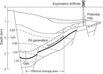
- Sketch of a simplified petroleum system showing source, migration and potential trap: A hydrocarbon-producing depression, or ‘kitchen’, displays a steeply dipping source rock layer that exhibits immature, mature and post-mature portions (modified from Hunt 1996; for details see Magoon & Dow 1994). Maturity is depicted by vitrinite reflectance in oil immersion (Ro). Oil generation is thought to start at RO = 0.62%, and gas with condensate below Ro = 1.0%. Hydrocarbons migrate upward and may collect in a structural trap. The effective drainage area is delimited by sufficient maturation and geological constraints.
Until now, however, reports of great new finds by application of mineral system analyses are rare apart from the publication of (yet untested) mineral potential sketch maps. A very instructive example is the comparison between mineral prospectivity modelling and the results of past exploration covering the important porphyry copper-gold province around Cadia and Northparkes mines in eastern Australia (Kreuzer et al. 2015). Another illuminating case is the companion paper on the “BIF-hosted iron mineral system” by Hagemann et al. (2016b).
Apart from Australia, few countries have the will and the resources to launch an innovation project such as Deep Earth Imaging (CSIRO 2017). The full data set described above will rarely be available. Patchy coverage will be as common as for traditional exploration and assumptions will have to be made. Limited funds will always be a hindrance. Yet, the systematic approach is a great step forward.
References
CSIRO (2017) Deep Earth Imaging. Accessed 20 April 2017. URL www.csiro.au
Hagemann, S.G., Lisitsin, V.A. & Huston, D.L. (2016a) Mineral system analysis: Quo vadis? Ore Geol. Reviews 76, 504–522. doi.org
Hagemann, S.G., Angerer, T., Duuring, P. et al. (2016b) BIF-hosted iron mineral system: A review. Ore Geol. Reviews 76, 317–359. doi.org
Hunt, J.M. (1996) Petroleum geochemistry and geology. 743 pp. Freeman.
Kreuzer, O.P., Miller, A.V.M., Peters, K.J. et al. (2015) Comparing prospectivity modelling results and past exploration data: A case study of porphyry copper-gold mineral systems in the Macquarie arc, Lachlan fold belt, New South Wales. Ore Geol. Reviews 71, 516–544. doi.org
Launay, L. de (1913) Traité de Métallogénie. 3 Vols. Paris.
Magoon, L.B. & Dow, W.G. (eds) (1994) The petroleum system from source to trap. AAPG Memoir 60, 1-655.
McCuaig, T.C., Beresford, St. & Hronsky, J. (2010) Translating the mineral systems approach into an effective exploration targeting system. Ore Geol. Reviews 38, 128-138.
Porwal, A.K. & Kreuzer, O.P. (2010) Introduction to the Special Issue: Mineral prospectivity analysis and quantitative resource estimation. Ore Geol. Reviews 38, 121-127.
Back to top
Home
Passing on a message from the Society of Economic Geologists (SEG) - Graduate Student Fellowship Program (14 April 2017)
“I have come finally to the key message of this column. Students, wherever you are studying, wherever you are currently living, if you are considering the pursuit of graduate studies in economic geology, I strongly encourage you to apply to the SEG Graduate Student Fellowship Program or one of the other SEGF funds, such as the McKinstry Fund, if appropriate. Please visit the SEG Graduate Student Fellowship web page (www.segweb.org/GSF) to see the minimum requirements and the application process.”
Stuart R McCracken (SEG Foundation President 2017)
Published in SEG Newsletter 109, April 2017
Back to top
Home
Dolomite — Magnesite — Metasomatism: New Insights! (15 March 2017)
Dolomite (also called dolostone) and magnesite rock of high purity and whiteness are highly valued in industrial applications. Usually, they are extracted from hard rock quarries, less often from underground mines. Typically, both form limited masses of 1-1000 Mt within marine limestones suites. Clearly, these bodies originated by chemical replacement of calcite (CaCO3) by dolomite [(CaMg(CO3)2 ] or magnesite (MgCO3), or in other terms, of partial or total replacement of Ca by Mg. The geological term for this replacement process is metasomatism. Sedimentary and diagenetic models of sparry magnesite metasomatism are closely related to concepts of dolomite formation.
Most commonly, the details and variable possibilities of ore body scale metasomatism in geological nature are discussed in geochemical terms, employing various isotopic systems or trace element characteristics. I will not deny that geochemical methods allow surprising new approaches to genetic modelling. On the contrary, concerning dolomite and magnesite, I'll just mention the novel use of Mg isotopes (Dong et al. 2016) or of clumped isotopes (Garcia del Real et al. 2016).
Generally, pre-Cenozoic metasomatic bodies have experienced repeated passage of fluids and heat events, fudging genetic signals. Geologically young and well-preserved metasomatic deposits of dolomite, magnesite or siderite are rare, however. Therefore I found it diverting to read a case study of Miocene dolomite formation in the Gulf of Suez (Hollis et al. 2017). For gas and oil geology, dolomite often is a profuse reservoir, but in this case, we only learn a lot about fault-bound hydrothermal dolomite formation by deep convection of ordinary seawater. The authors stress that the characteristic pattern of (1) non-stratabound massive dolomite along faults and of (2) stratabound lateral tongues into host rock is not synchronous but that (2) clearly precedes (1). Formation temperatures were estimated at ∼40–70 °C (stratabound) and at ∼40–100 °C for the massive dolomite; certainly hot enough for the term ‘hydrothermal’. For students of ‘sparry’ Veitsch-type magnesite, of hydrothermal dolomite, of metasomatic siderite, and of, among others, Irish-type base metals, this should be compulsory reading.
By the way, a recent comprehensive paper on Hohentauern/Sunk, one of the typical Austrian sparry magnesite deposits, provides many modern data and confirms diagenetic replacement (Azim Zadeh et al. 2015).
Fortunately, the Hollis et al. (2017) paper is Open Source classified. You may download and read it at your own leisure.
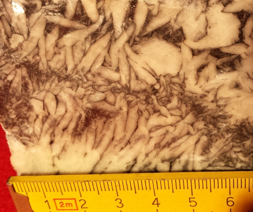
- Pinolite-textured magnesite from Hohentauern-Sunk Mine, Austria. Note the crystal rosettes and general displacement of formerly dispersed impurities by crystals growing during diagenesis. Typical for stratiform/stratabound metasomatites, the fabric is weakly sedimentary features preserving and crystals display cloudy core–clear rimmed fabrics.
References
Azim Zadeh, A.M., Ebner, F. & S.-Y. Jiang (2015) Mineralogical, geochemical, fluid inclusion and isotope study of Hohentauern/Sunk sparry magnesite deposit (Eastern Alps/Austria): implications for a metasomatic genetic model. Miner. Petrol. 109, 555-575.
Hollis, C., Bastesen, E., Boyce, A. et al. (2017) Fault-controlled dolomitization in a rift basin. Geology 45, 219-222.
Gold Open Access: This paper is published under the terms of the CC-BY license. geology.gsapubs.org
Garcia del Real, P., Maher, K., Kluge, T. et al. (2016) Clumped-isotope thermometry of magnesium carbonates in ultramafic rocks. Geochim. Cosmochim. Acta 193, 222–250.
Dong, A., Zhu, X.-K., Li, Sh.Zh., Kendall, B., Wang, Y., Gao, Zh. (2016) Genesis of a giant Paleoproterozoic magnesite deposit: Constraints from Mg isotopes. Precambrian Research 281, 673–683.
Back to top
Home
Arsenic: Well-drillers, be wary of water from reduced, grey sediments! (14 February 2017)
Unrelated to mining, natural arsenic concentrations in aquifers and/or groundwater of lowland valleys throughout the world are a hidden hazard. In the Ganges delta, this caused humanity's biggest mass poisoning. Earlier, millions of people in the region had relied on surface water. From 1980 to 1990 thousands of drinking water wells were drilled to provide ‘safe’, that is microbially clean water. Of these wells, nearly 50% had As of >10 micrograms/litre (WHO's limit). Sadly, this was only recognized after numerous people had developed skin and internal disorders, including cancer. With 2-20 ppm, the As-concentrations in Ganges river sediments are quite ordinary. Most As is adsorbed in Fe-oxide particles. Spots of elevated dissolved arsenic occur in low-sulphate groundwater in the presence of reactive organic matter, which supports microbial reduction of iron oxides and oxy-hydroxides; this releases adsorbed arsenic (Bowell et al. 2014). Pumping increases recharge, which may trigger aquifer flushing and release of Fe(II) and As(III). Well-drillers should keep samples oft grey sediments and water, and ask for advice. Various removal technologies are available; if nothing else is possible, a cheap and efficient precaution is stirring the contaminated well water with iron oxy-hydroxide fines.
Anthropogenic arsenic contamination is unfortunately not rare; mining, ore dressing, metallurgical processing (roasting plants and smelters) and general industry may be hotspots. I wonder how many of my readers work in mines that deal with elevated traces of arsenic, such as many of those extracting copper, gold, platinum and tin.
If you are seeking an example for how to professionally investigate a potentially dangerous situation, I recommend a recent paper that describes work done for an ecological risk assessment (ERA). The site of the study is the Neoarchaean (2.61 Ga) Siilinjärvi alkaline complex (16 x 1.5 km) in Eastern Finland that comprises carbonatite and syenite. Its core hosts an important deposit of apatite (an ore of phosphorus that is here the main mine product), glimmerite and calcite.
At the Yara Siilinjärvi industrial site, the apatite is treated with sulfuric acid to produce phosphorus fertilizers. The sulfuric acid in turn is made by roasting pyrite, of which some 860,000 tonnes per year are produced as a by-product of Cu and Zn at the nearby underground Pyhäsalmi mine.
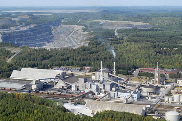
- Photograph showing Yara Siilinjärvi phosphate mine in Finland. Fertilizer plant in the foreground, calcined pyrite heaps in the background on the right. Courtesy Yara Suomi Oy.
The apatite mine, industrial plant as well as the calcined pyrite tailings storage heaps lie near a lake. Turunen et al. (2016) present an illuminating study of arsenic dispersion from the calcined pyrite tailings. The calcined pyrite consists of hematite; the tailings have a a high As content (500–654 mg kg-1) that is mobilized by seepage water, which is collected and reused as process water in the plant.
The natural (geogenic) background As concentrations are very low so that hydraulically and geochemically, the gradient from the tailings to the environs and the lake is considerable. As expected, in spite of retaining measures, the migration of As by dust and water reaches the lake and is recorded in its sediments. Analytical results of many samples near the tailings exceeded the European Chemical Agency's (ECHA) Predicted No Effect Concentrations (PNECs). For example, the As concentration in 64 % of the water samples exceeded the PNEC value for fresh water (0.5 l μg L-1). Dissolved arsenic and other potentially harmful metals brought in with the pyrite (Co, Cd, Cu and Ni) also pose a risk but the ubiquitous iron oxides retain and fix much of the metal load.
The paper by Turunen et al. (2016) is a rich source on geochemical methods and technologies used. It is highly recommended. And it is freely downloadable under creative commons licence!
References
Bowell, R.J., Alpers, Ch.N., Jamieson, H.E., Nordstrom, D.K. & Majzlan, J. (2014) The environmental geochemistry of arsenic -- an overview. Rev. Mineralogy & Geochemistry 79, 1-16. DOI: 10.2138/rmg.2014.79.1
European Chemicals Bureau (2003) Technical Guidance Document on Risk Assessment. European Communities. Available online at echa.europa.eu
Turunen, K., Backnäs, S., Neitola, R. & Pasanen, A. (2016) Factors controlling the migration of tailings-derived arsenic: A case study at the Yara Siilinjärvi site. Mine Water Environ 35, 407-420. Keywords include Arsenic fractionation; Arsenic mobility; Soil chemistry; Water chemistry; Risk assessment. Free download under creative commons licence. springer.com
Back to top
Home
Diamond crystals forming in a metallic Fe-Ni-C-S melt — did humans re-invent nature's secret? (17 January 2017)
In my last blog (8 December 2016) I referred to the role of subduction in the process system of gem diamond formation (Stern et al. 2016). Soon after I had this published, another brilliant paper appeared, that reports on the crystallisation of natural diamond from a metallic Fe-Ni-C-S melt (Smith et al. 2016).
Smith et al. (2016) investigated microinclusions in some of the famous great diamonds, such as the Cullinan from the Premier mine in South Africa, in rough weighing 3,106 carats, found in 1905. Based on common properties such as attribution to the low-N type II diamonds, large size and few but distinct microinclusions, the authors collected 53 similar diamonds. The microinclusions turned out to be magnetic solid phases crystallised from a metallic Fe-Ni-C-S liquid that was trapped during diamond growth. Like fluid or gas inclusions in minerals, silicate or metallic melt inclusions provide a wealth of genetic information. Other inclusions formed of silicates suggest that these diamonds formed in the mantle transition zone between 410 and 660 km depth. This is much deeper than the common gem diamonds that crystallised at the asthenosphere-lithosphere boundary (ALB) at 135-200 km. Several arguments support formation of this metallic melt within subducted eclogite. Light carbon isotopic compositions point to a crustal biogenic origin. The authors propose to call this specific group of type II diamonds CLIPPIR (Cullinan-like, inclusion-poor, pure, irregularly shaped, and resorbed).
Synthesis of diamond has been first attempted >100 years ago. Industrial production started some 60 years later. Today, most synthetic diamond is made from graphite in a metallic melt by the High Pressure/High Temperature (HPHT) technology at T>1400oC and P>59 kbar.
Industrial diamond is foremost an abrasive that is used for drilling, grinding, sawing and polishing. Useful properties apart from its hardness include toughness, resilience against aggressive chemicals and high-temperature stability. Applications are numerous, ranging from microsurgery to computer chip production, deep drilling for petroleum and cutting large monolithic dimension stones. Most of this market is served by synthetic monocrystalline and polycrystalline diamonds.
Only about 1% of the steadily growing demand for industrial diamonds is satisfied by mining natural diamonds. In 2015, world mine production of industrial grades reached 54 Mcts. China alone produces >4000 Mct/yr (or 800 tonnes) of synthetic diamonds (USGS 2017). Even the production of synthetic gem diamonds is possible, at a fraction of the price of natural diamonds. Is branding the ‘true’ stones a long-term solution?
-
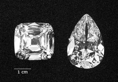
- The Cullinan was the largest diamond ever discovered. It was cut by Assher's in Amsterdam into 9 major gems and 96 small brilliants. The largest gem from the Cullinan is known as the Great Star of Africa, the largest cut diamond in the world. This and no. II are part of the British crown jewels. Here we see the stones no. IV and III. Source: Wikipedia public domain
References
Smith, E.M., Shirey, St.B., Nestola, F. et al. (2016) Large gem diamonds from metallic liquid in Earth's deep mantle. Science Vol. 354, Issue 6318, pp. 1403-1405. DOI: 10.1126/science.aal1303
Stern, R.J., Leybourne, M.I. & Tatsuki Tsujimori (2016) Kimberlites and the start of plate tectonics. Geology 44, 799-802. geology.gsapubs.org/
Back to top
Home
