2018 News Archive
Drilling through salt: Caution, it moves! (December 15, 2018)
Different deformation characteristics distinguish the various salt rocks, intercalated clays, sulfates and carbonates, and their host rocks. Salt rocks are less compentent and tend to flow, i.e. deform ductilely. A unique determination of salt flow in geological time dimension was acquired by Cartwright et al. (2018): Over 1.7 My, buried Messinian salt in the Levante flowed at an average velocity of 2 mm/yr, which equates to a shear strain rate of 4 x 10 to the power of minus 14 and a viscosity of 2.3 x 10 to the power of 18 Pa . s.
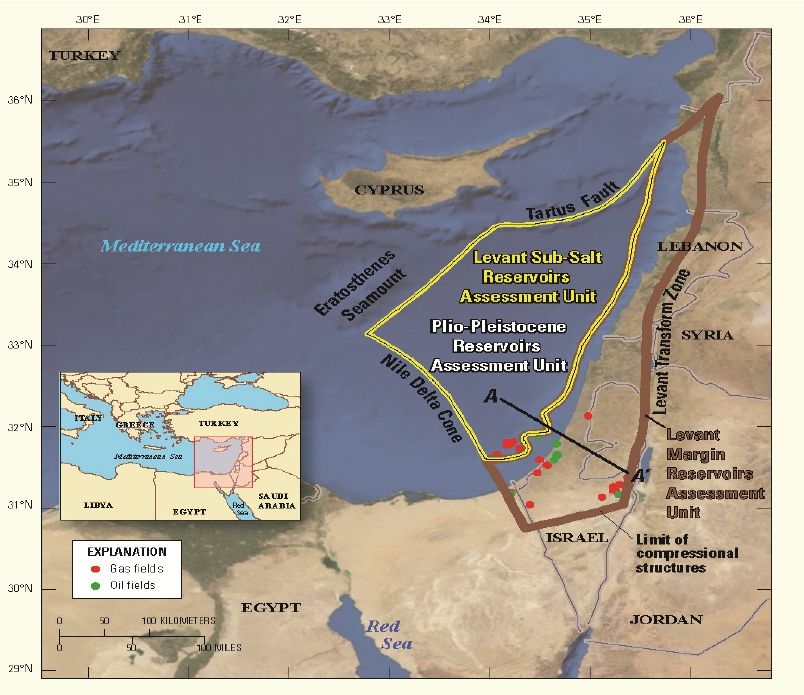
- Subsalt assessment unit and hydrocarbon fields in the Levant Basin of the Eastern Mediterranean (Wikipedia 2018)
The authors write: Three-dimensional (3-D) seismic imaging techniques are used to identify a series of 21 deformed fluid escape pipes that transected a 1500-m-thick salt sheet at regular intervals over the past 1.7 m.y. By reconstructing these pipes to their original vertical cylindrical geometry, we show that the salt sheet deformed by Couette flow over this period. The average flow velocity of the top boundary of 2 (plus minus 0.3) mm/yr, equates to a bulk viscosity for the sheet of 2.3 x 10 to the power of 18 Pa . s, within the range obtained from field and laboratory measurements. Similar fluid escape structures are expected to occur widely in salt basins due to the extreme fluid overpressure developed beneath the almost-impermeable salt. These structures offer a new approach for constraining basin-scale models of the kinematics of salt flow by the in situ measurement of flow geometry, with the potential to provide calibrations for experimentally derived flow laws for evaporite systems.
Couette flow is the flow of a viscous fluid in the space between two surfaces, one of which is moving tangentially relative to the other. In this case, ductile Messinian salt moves between a footwall and a hangingwall given by more competent, brittle sediments. In this newly discovered Levante hydrocarbon province, subsalt gas production holes might be impaired by the movement.
Fluid escape pipes through salt are remarkable features; they are probably restricted to deep basins that are hardly locations of salt mining, where they might have been encountered.
Referemce
Cartwright, J., Kirkham, Ch., Bertoni, C., et al. (2018) Direct calibration of salt sheet kinematics during gravity-driven deformation. Geology 46, 623-626. doi: 10.1130/G40219.1
Back to top
Home
Main Insights from E-African Tsavorite (Gem Quality Vanadium Grossular) Minerogenetic System Analysis (November 17, 2018)
Recently, as one of about 500 I participated in the 1st Conference of the Arabian Journal of Geosciences (CAJG) at Yasmine Hammamet, Tunisia. It was a great event and its supervisor, Dr. Nabil Khelifi, MENA Program (Springer) and his team, as well as the Tunisian conference team have done a marvellous job.
I was lucky to take part in a 3-day pre-conference field trip into western-central Tunisia led by Prof. Mabrouk Boughdiri, Ridha Maambri and Nejib Bahrouni. We saw remarkable geology such as the historic karst water source at Zaghuan, the hydrothermal karst fluorite and Pb-Zn deposit at Hammam Zriba, the Cretaceous/Paleogene boundary near El Kef, and the Eocene nummulite limestone mesa of Jugurtha Tableland, remains of the last Hothouse Earth period. Wherever we came, we experienced the warm hospitality of the locals. The Gala Dinner at El Kef will never be forgotten.
I spoke at CAJG on November 13, 2018, about `The tsavorite (gem quality vanadium grossular) minerogenetic system in East Africa (Pohl 2018b) . The presentation was to illustrate, summarize and update the short conference paper (Pohl 2018a), which I had submitted in early spring of the current year. You can find more background to tsavorites in my blog March 17, 2018, below.
You know that the trend of metallogenetic research and application is increasingly towards a systematic source-to-trap model. Applying this principle to the gem grossulars I presented the following main observations and conclusions:
You may notice that I differ in several important points from earlier interpretations and the most recent paper of the French tsavorite team (Jacob et al. 2018) but here is not the place to discuss details.
References
Jacob, J.-B., Martelat, J.-E., Goncalves, P., Giuliani, G., et al. (2018) New P-T-X conditions for the formation of gem tsavorite garnet in the Voi area (southwestern Kenya). Lithos 320 / 321, 250 / 264. doi.org/10.1016/j.lithos.2018.09.010
Pohl, W.L. (2018a) The tsavorite (gem quality vanadium grossular) minerogenetic system in East Africa. In: Proceedings of the 1st Conference of the Arabian Journal of Geosciences (CAJG-1), Tunisia 2018 (eds Rosetti et al.). Springer.
Pohl, W.L. (2018b) The tsavorite (gem quality vanadium grossular) minerogenetic system in East Africa. Presentation at the 1st Conference of the Arabian Journal of Geosciences (CAJG-1), Tunisia. Nov 13, 2018.
Thomas, R., Rericha A., Pohl, W.L. & Davidson, P. (2018) Genetic significance of the 867 cm-1 out-of-plane Raman mode in graphite associated with V-bearing green grossular. Mineralogy & Petrology 72, 1088-1101. https://doi.org/10.1007/s00710-018-0563-1
Back to top
Home
Carbon capture, utilization, and storage (CCUS) urgently needed to decarb the green biofuel industry! (October 10, 2018)
This is not about coal! Published in September 2018, this paper (Edwards & Celia 2018) describes how the so-called green biofuel industry may rapidly reduce its CO2 emissions in order to help keeping within the Paris climate agreement. The authors report that ethanol fermentation at biorefineries in the midwestern US is a major emission source of CO2 that could be halved by building a moderately-sized new network of CO2 pipelines. Carbon dioxide from ethanol fermentation constitutes most of the midwestern low-capture-cost emissions (35 Mt per year and 90% of the Midwest total). Edwards & Celia base their financial evaluation on substantial new tax credits passed by the US Congress in February 2018, that incentivize new CCUS projects.
In 2017, the USA output of CO2 was ~5000 Mt (15% of the world total), slowly falling. Biofuels production was ~37 Mt (toe) and growing at 2.9% annually (BP Statistical Review of World Energy 2018) .
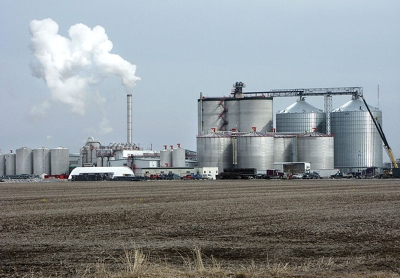
- A typical ethanol plant in West Burlington, Iowa (Big River Resources, LLC). Photo by Steven Vaughn. Wikimedia Commons.
Read Edwards & Celia (2018) Abstract:
Carbon capture, utilization, and storage (CCUS) is a crucial technology needed to limit warming to the 2 degrees C target of the Paris Agreement. However, deployment is lagging far behind estimates of what is required. Globally, only 31 million metric tons (Mt) per year of anthropogenic carbon dioxide are currently captured and injected into geological formations for permanent storage.
We demonstrate an opportunity to significantly expand CCUS in the United States in the near-term, spurred by new financial incentives enacted in February 2018, by targeting the lowest-cost capture opportunities and by deploying only commercially proven technologies. The carbon dioxide pipeline transport network would serve near-term oil industry demand for carbon dioxide while also connecting multiple prospective long-term dedicated geological storage resources. This would be a flexible long-term infrastructure asset for carbon management in the United States that would enable and accelerate future CCUS deployment. In February 2018, the United States enacted significant financial incentives for carbon capture, utilization, and storage (CCUS) that will make capture from the lowest-capture-cost sources economically viable. The largest existing low-capture-cost opportunity is from ethanol fermentation at biorefineries in the Midwest. An impediment to deployment of carbon capture at ethanol biorefineries is that most are not close to enhanced oil recovery (EOR) fields or other suitable geological formations in which the carbon dioxide could be stored. Therefore, we analyze the viability of a pipeline network to transport carbon dioxide from Midwest ethanol biorefineries to the Permian Basin in Texas, which has the greatest current carbon dioxide demand for EOR and large potential for expansion. We estimate capture and transport costs and perform economic analysis for networks under three pipeline financing scenarios representing different combinations of commercial and government finance. Without government finance, we find that a network earning commercial rates of return would not be viable. With 50% government financing for pipelines, 19 million tons of carbon dioxide per year could be captured and transported profitably. Thirty million tons per year could be captured with full government pipeline financing, which would double global anthropogenic carbon capture and increase the United States carbon dioxide EOR industry by 50%. Such a development would face challenges, including coordination between governments and industries, pressing timelines, and policy uncertainties, but is not unprecedented. This represents an opportunity to considerably increase CCUS in the near-term and develop long-term transport infrastructure facilitating future growth.
This is only one of many possible contributions of the geosphere to mitigation of CO2 emissions into the atmosphere. Why not encourage more research, innovation and development? Is yesterdays call for unprecedented changes by ICCP possibly premature?
BP (2018) BP Statistical Review of World Energy. 49 pp. 67th ed. URL https://www.bp.com/en/global/corporate/energy-economics/statistical-review-of-world-energy.html. June 2018. Open Access.
Edwards, R.W.J. & Celia, M.A. (2018) Infrastructure to enable deployment of carbon capture, utilization, and storage in the United States. PNAS 115, E8815-E8824. PNAS Table of Contents for September 18, 2018; Vol. 115, No. 38 E8815-E8824; published ahead of print September 4, 2018 (online I bought a PDF for 10 US $). https://doi.org/10.1073/pnas.1806504115
Back to top
Home
Trajectories of the Earth System in the Anthropocene (August 15, 2018)
This is the title of a truly remarkable paper that appeared a couple of days ago. Remarkable, because of its radicality and the profuse Supporting Information. And, it can be freely downloaded from the PNAS website!
Unfortunately at this time, I am working day and night on a project and cannot really comment on the contents. But I can say that this is great thinking and that all Earth scientists and practicians of Earth Science should be informed.
I still hesitate to accept the term Anthropocene as a geological epoch, however, and I am critical of the authors tendency to continue with the traditional climate business although they ask much more of the same. But nevertheless, their paper is brilliant!
Steffen, W., Rockstroem, J., Richardson, K., et al. (2018) Trajectories of the Earth System in the Anthropocene. Proc. Natl. Acad. Sci. USA 115, 8252-8259.
Abstract
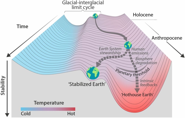
We explore the risk that self-reinforcing feedbacks could push the Earth System toward a planetary threshold that, if crossed, could prevent stabilization of the climate at intermediate temperature rises and cause continued warming on a Hothouse Earth pathway even as human emissions are reduced. Crossing the threshold would lead to a much higher global average temperature than any interglacial in the past 1.2 million years and to sea levels significantly higher than at any time in the Holocene. We examine the evidence that such a threshold might exist and where it might be. If the threshold is crossed, the resulting trajectory would likely cause serious disruptions to ecosystems, society, and economies. Collective human action is required to steer the Earth System away from a potential threshold and stabilize it in a habitable interglacial-like state. Such action entails stewardship of the entire Earth System biosphere, climate, and societies and could include decarbonization of the global economy, enhancement of biosphere carbon sinks, behavioral changes, technological innovations, new governance arrangements, and transformed social values.
Subtitle of Figure 2: Stability landscape showing the pathway of the Earth System out of the Holocene and thus, out of the glacial interglacial limit cycle to its present position in the hotter Anthropocene. Currently, the Earth System is on a Hothouse Earth pathway driven by human emissions of greenhouse gases and biosphere degradation toward a planetary threshold at 2 degrees C, beyond which the system follows an essentially irreversible pathway driven by intrinsic biogeophysical feedbacks. The other pathway leads to Stabilized Earth, a pathway of Earth System stewardship guided by human-created feedbacks to a quasistable, human-maintained basin of attraction. Stability (vertical axis) is defined here as the inverse of the potential energy of the system. Systems in a highly stable state (deep valley) have low potential energy, and considerable energy is required to move them out of this stable state. Systems in an unstable state (top of a hill) have high potential energy, and they require only a little additional energy to push them off the hill and down toward a valley of lower potential energy.
PNAS August 14, 2018. 115 (33) 8252-8259; published ahead of print August 6, 2018. doi.org/10.1073/pnas.1810141115
Back to top
Home
Mount Weld Rare Earth Element (REE) Mine, Australia (July 18, 2018)
Lateritic blankets of regolith above carbonatite are at present often deposits of niobium (e.g. Araxa, Brazil) and/or phosphate. Most display enrichment of REE, but profitable recovery from apatite is not easy. However, production from lateritic ore with leachable REE can be profitable:
At the volcanic Mt. Weld carbonatite plug and maar in Western Australia (2025 Ma), JORC reserves are reported as ~10 Mt at 11% REO + Y. The estimate is based on a cut-off grade of 2.5% REO (Lynas Corporation 2018). The high grades are due to supergene enrichment. Ore comprises pyrochlore, REE-rich residual apatite and secondary Th-depleted monazite disseminated in fine-grained iron oxides. REE ore minerals are concentrated by flotation to ~40% REO. Further processing takes place in Malaysia. Recovery aims first at REE and may later include phosphate, Nb, Ta and Y (3.1%). At present, the main product is NdPr.
Within a volcano-sedimentary greenstone belt of the Yilgarn craton, a circular aeromagnetic and high-density anomaly led to discovery of Mt. Weld (Pirajno et al. 2017). Lynas Corporation acquired the property in 2011 and developed the mine. Unaltered soevite carbonatite comprises calcite, dolomite, apatite, magnetite and pyrochlore. Its globular textures indicate an origin as fluidized vent material (Pirajno et al. 2017). Leaching of calcite and supergene alteration produced the 10-90 m thick mineralized regolith.
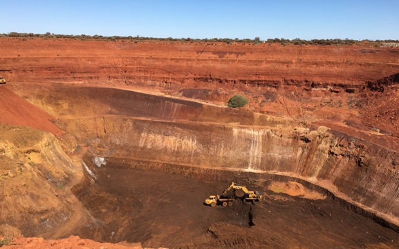
- The photograph shows the main pit at Mt. Weld. Light and dark rocks in the lower part differ by Fe-oxide contents. Higher Fe correlates with high REE grade. The horizontally bedded cover are Cretaceous lake and swamp sediments. Credit Lynas Corporation 2018.
Lynas Corp. ist listed on the Australian stock exchange (ASX code LYC). After ups and downs its share value was at 2 A$ on July 18, 2018 (www.asx.com.au). On the company website (https://www.lynascorp.com/), there is ample information on financial matter, mining and reserves/resources, but for a professional, little geological detail.
References
Pirajno, F., Gonzalez-Alvarez, I., Border, A. & Porter, T.M. (2017) Mt. Weld and Gifford Creek rare elements carbonatites. Pp 163-166 in Australian Ore Deposits (ed G.N. Phillips), Australasian Institute of Mining and Metallurgy.
JORC (2012) Australasian Code for Reporting of Exploration Results, Mineral Resources and Ore Reserves (The JORC Code). Available from: jorc.org (The Joint Ore Reserves Committee of The Australasian Institute of Mining and Metallurgy, Australian Institute of Geoscientists and Minerals Council of Australia).
Back to top
Home
Is lateral secretion an ore-forming process? (June 11, 2018)
What is lateral secretion? -- According to the American Geological Institute (AGI) Glossary of Geology (Neuendorf et al. 2006), lateral secretion is a theory of ore genesis first formulated in the 18th century and passing in and out of use since. It postulates the formation of ore deposits by the leaching of adjacent wall rock. Then, the authors describe the current use as convective fluids driven by cooling plutons.
In my Economic Geology book (EG, Pohl 2011) I did not follow the remainder of the AGI definition because linguistically, secretion is the act or product of secreting (eg a substance produced by a gland), or mineral matter formed by inward growth in a cavity (The Chambers Dictionary 10th Edition 2006).
The genetic model that I sketched in 2011 (EG: page 127) consisted of metamorphic fluids segregated from a rock during metamorphic dehydration, sucked into a fissure, not convecting and, opposed to the metamorphogenic-hydrothermal model, not moving over great distances. In 2011, I doubted that lateral secretion can form ore (a body of ore or minerals that is of economic interest).
But I erred. Meanwhile, as a co-author in Thomas et al. (2018) I published a case of lateral secretion where a handful of gemstones may have the same value as a million tonnes of metal ore.
Read the updated version of my 2011 text on lateral secretion:
Lateral secretion is different from metamorphogenic ore formation. It is best exemplified by the common and ubiquitous generation of quartz and carbonate veinlets from host rocks at low metamorphic grades and of pegmatitic mobilizates at high grades. This interpretation is confirmed by the clear correlation between the paragenesis of the secretion veins (also called segregation veins) and the chemistry of the enclosing rocks: Quartz mobilizates, for example, occur in siliceous metasediments, whereas calcite veinlets form in limestone marble and in basic metavolcanic rocks. In the latter case, veinlets include epidote, chlorite and sulfides. Lateral secretion veins are mostly tensile structures that originate in syn- to late-metamorphic stages. Lateral secretion should result in a balanced mass exchange between host rocks and veins. Mobilized elements in the first decrease in concentration with proximity to the veins. Because of the chemical equilibrium between fluids and rocks, lateral secretion imprints no hydrothermal alteration on host rocks and stable isotopes reflect an equilibrium: Fluids and dissolved matter, or liquids are of local derivation. A transient pressure gradient induces movement of fluids or liquids that are initially dispersed in the rocks, to the opening fissure. Fluids/liquids move along grain boundaries, microcracks or by diffusion. This system is spatially limited and essentially closed. In its pure form there is no inflow from beyond its boundary and little outflow. In tectonically quiescent times, temperature and pressure in the fissure and the country rocks are equal, but pressure drops where extensional strain creates a fissure (see Figure).
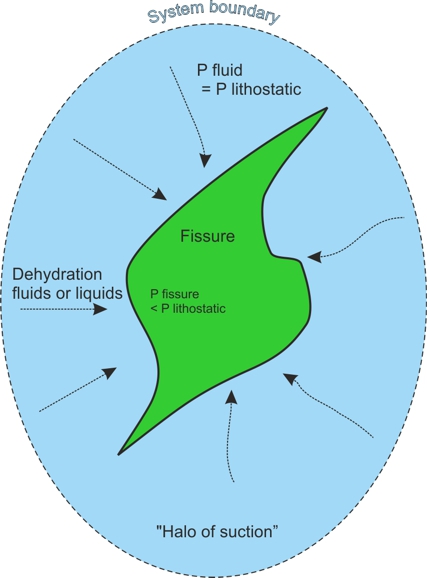
- Principles of lateral secretion (adapted from Pohl 2011). Changes in the orogenic stress field lead to opening of a fissure. The resulting pressure gradient (P fissure < P lithostatic = P fluid) enforces flow of metamorphic fluids or liquids into the fissure where minerals precipitate. The system is closed within narrow limits (Halo of suction). The fluids are dilute solutions (or partial melts) of the surrounding host rock.
Background fluid pressure is lithostatic. Because of the limitations concerning the mass of participating fluids and dissolved matter, a lateral secretion system is not expected to form economic metallic or mineral deposits (apart from pockets of gems or rare mineral specimen). Lateral secretion veinlets demonstrate the possibility of a temporary retention of metamorphic fluids or liquids in a dehydrating hot rock body.
A case that fits lateral secretion resulting in gold ore formation was described by Tomkins (2007): Metamorphism often causes a loss of sulfur and formation of pyrrhotite or magnetite from pyrite (desulfidation). This sulfur is dissolved in prograde dehydration fluids (e.g. water from breakdown of chlorite), at low T in the form of H2S and S3- at high T. By forming thiocomplexes, these fluids may mobilize metals such as gold and silver that were hosted in original pyrite/arsenopyrite. Precipitation commonly takes place in the immediate wall rocks, where the fluids encounter minerals with reduced iron. In this way, metamorphic lateral secretion type ore of pyrrhotite, gold and silver can be formed.
References
Neuendorf, K.K.E., Mehl, J.P. & Jackson, J.A. (eds) (2005) Glossary of Geology. 5th edn. 779 pp. American Geological Institute.
Pohl, W.L. (2011) Economic Geology, Principles and Practice: Metals, Minerals, Coal and Hydrocarbons. An Introduction to Formation and Sustainable Exploitation of Mineral Deposits. 663 pp. Wiley Oxford.
Thomas, R., Rericha A., Pohl, W.L., Davidson, P. (2018) Genetic significance of the 867 cm-1 out-of-plane Raman mode in graphite associated with V-bearing green grossular. Mineralogy and Petrology 112 (5), 633-645. https://doi.org/10.1007/s00710-018-0563-1.
Tomkins, A.G. (2007) Three mechanisms of ore re-mobilisation during amphibolite facies metamorphism at the Montauban Zn-Pb-Au-Ag deposit. Miner. Deposita 42, 627-637.
Back to top
Home
The Nobel Brothers, Caucasian-Caspian Oil and the Maikop Source Rocks (May 18, 2018)
The Caucasus-Caspian region was the site of the first major oil rush outside of the United States after in 1870, oil had been found near Titusville, Pennsylvania. When in the same year the Russian empire relinquished the oil monopoly, an explosion of entrepreneurship was released (Yergin 2009). Three years later, Robert Nobel, the oldest of the three famous brothers, visited Baku, at that time a small trading town in Russia, with the intention to buy walnut wood for army rifle stocks. He realized at once the business opportunity, bought petroleum wells and a distillery instead of wood, and launched a business that was soon a highly integrated oil combine closely competing with Rockefeller's American enterprise. Ludwig Nobel became the Oil King of Baku, brother Alfred (the founder of the Nobel Price) helped with financing. In the 19th century, oil drilling was in its infancy and scientific understanding was quite limited, but Ludwig employed the first professional petroleum geologist ever.
In our days, petroleum systems are well understood and for conventional deposits, the source - migration - trap scheme is applied. Because unconventional oil and gas deposits, in which source and deposit are one, are economically very attractive, source rocks are of high interest.
For several years already, a group led by Prof. Sachsenhofer of Leoben University, Austria, investigates source rocks of the Tertiary epicontinental Paratethys Sea that evolved in the foreland of the Alpine-Caucasus mountain chain. Frequent stages of isolation from global oceans caused dysoxic and anoxic conditions in sub-basins of the Paratethys. This bequeathed organic matter-rich sediments that became source rocks for numerous oil fields.
The Maikop Group, developed in the Caucasus region, is considered to be one of the profuse source rocks of the eastern Paratethys, possibly charging Ludwig Nobel's oil fields. Along Belaya River in southern Russia, the Sachsenhofer group sampled a section of about 10 km length covering the total thickness of the Maikop Group (600 m) with ~200 samples (Sachsenhofer et al. 2017). In their paper, they provide a wealth of detailed data, such as lithology, paleontology, TOC, S, and Rock-Eval characteristics (pyrolysis data such as S1, S2, Tmax, and HI, the hydrogen index). In this region, the Maikop is immature; meaning that its kerogen with an average vitrinite reflectance of 0.30% Rr has not reached the oil producing stage. Along the Belaya River outcrops of the Maikop, most samples display the character of source rock but only part of the kerogen is marine and oil prone. TOC contents range from less than 1 to greater than 3 wt. %. Average HI is rather low (<300 mg HC/g TOC) as is Rock-Eval HC yield (Sachsenhofer et al. 2017).

- Sampling oil shale along the Belaya River, north of the Caucasus Mountains. Courtesy R.F. Sachsenhofer, Mining University Leoben.
In the photograph, a prominent white bed is seen embedded within brown organic-rich clay. This is the Polbian (Ostracoda) Bed, a marker horizon of less than 1 m thickness, characterized by brackish-water mollusks, nannoplankton, diatoms, ostracodes, and dinocysts. Maximum TOC (3.5 wt. %) and HI (420 mg HC/g TOC) were measured approximately 7.5 m above the Polbian Bed in calcareous clay. The true HI of this interval is as high as 575 mg HC/g TOC indicating the presence of kerogen type II. The Polbian is a limestone nearly free of organic matter. It is interpreted to reflect a Paratethys-wide significant decrease in salinity resulting from a temporary isolation from the world oceans (Sachsenhofer et al. 2017).
Allow me final note - 600 m of siliceous oil shale with a huge energy content, although of low grade, of near surface horizontal disposition is a great potential future asset. In view of the rich oil fields from the Black Sea to the Caspian Sea, with the city of Maikop one of the centres, the authors (Sachsenhofer et al. 2017) suggest that other source rocks such as an Eocene horizon might have charged the oil fields that were hitherto attributed to the Maikop source rocks.
References
Sachsenhofer, R.F., Popov, S.V., Akhmetiev, M.A., et al. (2017) The type section of the Maikop Group (Oligocene-lower Miocene) at the Belaya River (North Caucasus): Depositional environment and hydrocarbon potential. AAPG Bulletin 101, 289-319.
Yergin, D. (2009) The Prize. 908 pp. Simon & Schuster, Free Press.
Back to top
Home
Less than Two Weeks to go: Submit your Abstract for the 1st Conference of the Arabian Journal of Geosciences! Extended to May 15 (May 6, 2018)
The 1st CAJG conference will take place from November 12-15, 2018 at Hammamet, Tunisia. Hosts are Abdullah Al-Amri (Founder & Editor-in-Chief of the Arabian Journal of Geosciences) and Nabil Khelifi (Senior Editor, MENA Program, Springer, Germany).
Here is the link/URL to the conference website:
Deadline for submissions: 15 May 2018
Back to top
Home
Melt Inclusions and the Origin of Tsavorite: A Breakthrough! (March 17, 2018)
For several years I have learnt to admire the work of Rainer Thomas who is one of the few scientists mastering the techniques of investigating melt inclusions (MI). Frozen melt inclusions are common in most igneous rocks. They are similar to fluid inclusions in their capability to preserve chemical and P/T data that allow genetic insights. Rainer's results in using MI in pegmatite formation research first inspired my interest (e.g. Thomas & Davidson 2016, and earlier work).
Tsavorites are gem quality green grossularites and have always been explained to have crystallized from metamorphic fluids. Rainer's fascinating discovery concerns the existance and important role of a supercritical melt/fluid (SCMF) phase in pegmatite ore formation. This SCMF phase can contain widely varying percentages of volatiles and has strange properties, similar to but not identical to supercritical fluids.
A couple of years ago, when I had a chance to visit one of the tsavorite mines in SE Kenya, where earlier I had done geological mapping (Pohl et al. 1979), I connected the two strings and decided to ask Rainer if he would cooperate in order to unravel the origin of these rare gemstones. In sections of the samples I brought from Scorpion mine, Rainer soon discovered numerous melt inclusions but also graphite that is at present one of his main research interests. The resulting paper by Thomas et al. (lately accepted for print by MINPET) puts the hard data on the table and provides our interpretations. For the tsavorites, just read the last sentences of the Abstract below.
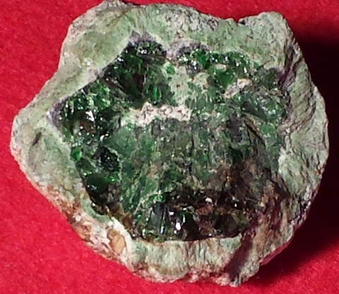
- Green grossularite garnet (about 25 mm across), idiomorphic, cataclastic; with a kelyphitic rim (5 mm) of bluish tanzanite (a V-zoisite), epidote, clinopyroxene, spinel, quartz and scapolite. Collected by WLP at Lualenyi Mine (Mgama Ridge).
Citation and Abstract:
Thomas, R., Rericha A., Pohl, W.L., Davidson, P. (2018) Genetic significance of the 867 cm-1 out-of-plane Raman mode in graphite associated with V-bearing green grossular. Mineralogy and Petrology 112 (5), 633-645. doi.org/10.1007/s00710-018-0563-1
SE Kenya is the world's largest producer of green vanadium grossular gemstones (tsavorite). Samples from one of the mines near Mwatate, and of occurrences in Tanzania yielded remarkable new insights into the genesis of tsavorite. Graphite is intimately associated with V-grossular and is one of the keys to understanding its origin. In the course of this study we found five different types of graphite. Surprisingly,in one graphite type the "Raman-forbidden" and IR-active 867 cm-1 band was observed. In this communication, we attempt to find an explanation for this unusual phenomenon. Additionally, our observations also address some of the issues pertaining to the origin of the green grossular-dominated rocks (grossularites), as well as the gem quality tsavorite crystals, since we propose that the anomalous spectroscopic behavior of the graphite is related to the unusual conditions during crystallization of both the grossular and graphite from a near-supercritical volatile- and sulfur-rich silicate melt. The massive green vanadium grossular contains abundant unequivocal crystallized melt inclusions, while the transparent gem quality grossular (tsavorite) displays only fluid inclusions. On the basis of inclusion studies we suggest that anatectic melts originated in the peculiar evaporitic host lithology of the tsavorite deposits. Near peak metamorphic temperatures (~700 degrees C) these liquids occurred as a supercritical volatile-rich "fluid/melt phase" characterized by complete miscibility between H2O and silicate liquid. Relatively dry liquid batches precipitated nontransparent green grossular, whereas wet batches segregated fluids that formed transparent tsavorite.
References
Pohl, W.L., Nauta, W.J., Niedermayr, G. (1979) Geology of the Mwatate Quadrangle and the Vanadium Grossularite Deposits of the Area (with a Geological Map 1:50,000). Kenya Geol Survey Report No. 101, Nairobi. https://www.researchgate.net/profile/Walter_Pohl
Thomas, R. & Davidson, P. (2016) Revisiting complete miscibility between silicate melts and hydrous fluids, and the extreme enrichment of some elements in the supercritical state: Consequences for the formation of pegmatites and ore deposits. Ore Geology Reviews 72, 1088-1101. doi: 10.1016/j.oregeorev.2015.10.004
Back to top
Home
Open access paper: Review of passive systems for acid mine drainage treatment (February 13, 2018)
If you should be working in a mine that emits acid mine drainage, and you want to learn more about how to deal with that, this paper by Skousen et al. (2017) published in the journal Mine Water and the Environment is a great source of the basic science and its application.
Read the Abstract:
When appropriately designed and maintained, passive systems can provide long-term, efficient, and effective treatment for many acid mine drainage (AMD) sources. Passive AMD treatment relies on natural processes to neutralize acidity and to oxidize or reduce and precipitate metal contaminants. Passive treatment is most suitable for small to moderate AMD discharges of appropriate chemistry, but periodic inspection and maintenance plus eventual renovation are generally required. Passive treatment technologies can be separated into biological and geochemical types. Biological passive treatment technologies generally rely on bacterial activity, and may use organic matter to stimulate microbial sulfate reduction and to adsorb contaminants; constructed wetlands, vertical flow wetlands, and bioreactors are all examples. Geochemical systems place alkalinity-generating materials such as limestone in contact with AMD (direct treatment) or with fresh water up-gradient of the AMD. Most passive treatment systems employ multiple methods, often in series, to promote acid neutralization and oxidation and precipitation of the resulting metal flocs. Before selecting an appropriate treatment technology, the AMD conditions and chemistry must be characterized. Flow, acidity and alkalinity, metal, and dissolved oxygen concentrations are critical parameters. This paper reviews the current state of passive system technology development, provides results for various system types, and provides guidance for sizing and effective operation.
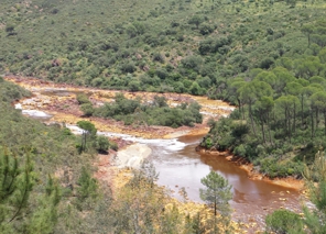
- Famous Tinto River some kilometers downstream of the large brownfield Rio Tinto copper mining area in SW Spain. For the background, read my blog about RIO TINTO Brownfield Mines - Remediate or Extract Remaining Resources? (25 May 2016). The photo dates from the wet season, when the water is not red and the pH tends towards neutral. Riparian vegetation is healthy but the banks are marked by ochreous iron oxy-hydroxides such as hydronium jarosite (yellow) and goethite. Such rivers can be remediated by limestone sand treatment (Skousen et al. 2017).
Keywords (my choice): Anoxic limestone drains; Bioreactors; Design and construction; How do they work; Limestone leach beds; Limestone sand treatment for whole watersheds; Low-pH Fe oxidation channels; Open limestone channels; Wetlands.
References
Skousen, J., Zipper, C. E., Rose, A. et al. (2017) Review of passive systems for acid mine drainage treatment. Mine Water Environ (2017) 36:133-153. Open access. link.springer.com
Back to top
Home
Hot early Earth (4500 to ~2500 Ma) - Lid Tectonics and Metallogeny (January 05, 2018)
The Earth's mantle is the ultimate source of many ore forming systems. According to present-day understanding, the mantle formed during accretion and melting of meteoritic matter, although perhaps the meteorites in our collection are not particularly good examples of Earth's building blocks (Carlson 2017). The magma ocean stage facilitated differentiation of the metallic core that collected the siderophile elements (Table 1.1) producing the primitive mantle composition (Allegre 2008). For the following ~2 billion years, the early Earth was covered by a thin, stagnant lithosphere with a komatiite-basalt crust (the lid) that enclosed the planet interior. Episodically, heat accumulation was released by mantle overturn events that produced giant ourpourings and the first patches of continental crust (lid tectonics, Bedard 2018).
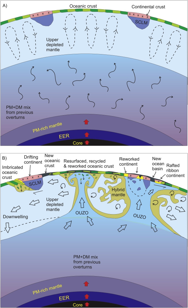
- Scaled cartoon illustrating an Archaean stagnant-lid crust and mantle overturn system. (A) Between overturn events (sometime between 3.9 and 2.7 Ga), Earth's surface is a mosaic of basalt - komatiite shield volcanos (green). (B) During a mantle overturn event, thermally buoyant lower mantle ascends as large plume-like structures. Courtesy Jean H. Bedard (2018).
The Earth appears to be unique among planets so far known in space by an evolution towards plate tectonics and life. Early Earth, however, resembled other rocky planets and moons by the formation of a stagnant shell (a lid) enclosing a convecting hot mantle. Episodic overheating resulted in cracking of the lid, mantle overturn, fissure eruption of basalts and komatiites, and differentiation of felsic melts that formed first embryonic patches of typical Archaean crust. Orogeny was driven by imbrication or subcretion ahead of drifting microcontinents (Bedard 2018). The transition from lid tectonics to plate tectonics was local and gradual until 2.5 Ga, when plate tectonics took over.
Bedard (2018) proposes a model of an Archaean stagnant-lid crust and mantle overturn system including lid tectonics with some brief references concerning metallogeny. In my words: Within the basalt-komatiite units, thick BIF (Algoma type banded iron formations) and chert sequences are intercalated. Komatiite ores are rivers of nickel sulfide. Archaean volcanogenic polymetallic massive base metal-sulfide (VMS) deposits may have formed from fluids mobilized by reheating of the fissured porous submarine volcanic pile, caused by new magma pulses. The deep sections of imbricated foreland terranes are the source of gold-carrying metamorphic fluids, resulting in orogenic Au deposits.
Gold quartz-vein ore at Kalgoorlie (Western Australia) is dated at 2651 +/- 9 Ma. The Golden Mile (1700 t Au) and many other orogenic-class deposits in the region are spatially associated with stocks and dykes of high-Mg calc-alkaline monzodiorite-tonalite porphyry, part of a late-orogenic (2665-2645 Ma) mantle-derived magnetite-series suite of adakitic affinity (Mueller et al. 2016). The abundance of Au-Ag telluride ore (15-20 % of total gold) in the Golden Mile has prompted comparison to the intrusion-related gold telluride deposits common in Cenozoic magmatic arcs. Is the Golden Mile a suprasubduction deposit? Should it be separated from the orogenic-type group?
Lid tectonics are not consolidated and much work remains to be done (Bedard 2018). Studies of Archaean metallogeny (e.g. Phillips 2017) are yet to include the new concepts.
References
Bedard, J.H. (2018) Stagnant lids and mantle overturns: implications for Archaean tectonics, magma genesis, crustal growth, mantle evolution, and the start of plate tectonics. Geoscience Frontiers 9, 19-49. doi.org/10.1016/j.gsf.2017.01.005 Open access. Open Access funded by China University of Geosciences (Beijing)
Mueller, A.G., Hagemann, St.G. & McNaughton, N.J. (2016) NeoArchean orogenic, magmatic and hydrothermal events in the Kalgoorlie-Kambalda area, Western Australia: constraints on gold mineralization in the Boulder Lefroy-Golden Mile fault system. Miner. Deposita 10.1007/s00126-016-0665-9
Phillips, N. (ed) (2017) Australian ore deposits. Monograph 32, 6th ed. 879 pp. Australasian Institute of Mining and Metallurgy.
Back to top
Home
